| Miles Kms | Item | Summary |
|---|---|---|
| 0.0 0.0 |
Junction of Highway # 160 - Welcome to Colorado |
Colorado Highway 145 starts at eastern portion of Cortez, Colorado, off Highway 160. It starts in a northeasterly direction. Part of this Highway Travel Guide Is called 'San Juan Skyway', a National Scenic Byway. |
| 7.9 12.7 |
Anasazi Heritage Site/McFee Reservoir |
The Anasazi Heritage Center is to the left, and turnoff to McFee Reservoir, one of Colorado's largest, is to the right. |
| 8.6 13.8 |
Mancos turnoff. |
Highway 184 turns right to Mancos. |
| 9.2 14.8 |
Dolores River |
At this point, the Dolores River is crossed. |
| 9.5 15.3 |
Dolores, Colorado |
Enter Dolores, elevation 6936. It is a small ranching/fishing/outdoors town, from which 145 climbs into the mountains. |
| 17.0 27.4 |
Dolores River |
The Dolores River, a great fishing and rafting river, begins to parallel 145 and does so for several miles. |
| 19.5 31.4 |
Line camp |
To the east side of the road is a line camp/chuckwagon/horseback riding attraction. |
| 22.2 35.7 |
San Juan Colorado National Forest |
Pass boundary to San Juan National Forest. Red sandstone cliff parallel the road for a few miles. |
| 26.0 41.8 |
Stoner, Colorado |
The small community of Stoner lies principally on the west side of the road. |
| 26.5 42.6 |
Ranch valley |
A beautiful ranch lies to the east and south side of the road as 145 curves temporarily east. |
| 29.5 47.5 |
Taylor Creek NFA |
Taylor Creek National Forest Access is to the east side of the road. |
| 33.7 54.2 |
Bear Creek trailhead. |
Bear Creek trailhead is to the east side of the road. |
| 35.4 57.0 |
Priest Gulch |
Priest Gulch Campground is on the east side of the road. |
| 37.1 59.7 |
Hillside NFA |
Hillside Drive National Forest Access is at this point. |
| 38.7 62.3 |
Roaring Fork NFA |
Roaring Fork National Forest Access is at this point. |
| 44.3 71.3 |
Scotch Creek NFA |
Scotch Creek National Forest Access turnoff is to the east. |
| 46.2 74.3 |
Rico |
Enter Rico, a former mining boomtown, elevation 8827. |
| 47.3 76.1 |
Atlantic Mine |
The Atlantic Mine structure is right along the road on the west side. |
| 48.5 78.0 |
Information station |
The information station for the San Juan National Forest is on the east side of the road. |
| 51.9 83.5 |
Beaver ponds |
Note beaver ponds on west side of the road. |
| 53.3 85.8 |
Cayton camping |
Cayton campground lies on the east side of the road. |
| 53.8 86.6 |
Dunton, Colorado |
Turnoff to small former ghost town of Dunton is to the west. Revitalization has been undertaken. You will pass by a beautiful valley on the way. |
| 56.2 90.4 |
Dolores River fades |
The Dolores River parallels 145 for many miles. Then it heads east just as 145 reaches Lizard Head Pass. |
| 57.2 92.1 |
Lizard Head |
A good view of Lizard Head can be seen to the west. See accompanying photo. |
| 57.2 92.1 |
Photo |
View from highway of Lizard Head |
| 57.4 92.4 |
East Fork Trail NFA |
East Fork Trail National Forest Access is to the east. |
| 59.5 95.8 |
Lizard Head Pass/trail |
Lizard Head Pass, elevation 10,222 feet, Lizard Head Trailhead, and rest area are at this point. Access to trailhead and rest area are on the west side of the road. |
| 61.0 98.2 |
Trout Lake |
The awesome sight of Trout Lake is to the east.
See accompanying photo. |
| 62.4 100.4 |
Matterhorn Campground |
The Matterhorn Campground, a National Forest recreation site, lies on the east side of the road. |
| 63.5 102.2 |
Ilium Valley |
As 145 turns east, a beautiful view of the Ilium Valley below can be seen to the north. |
| 64.0 103.0 |
Ophir Wall |
The Ophir Wall can be seen for a short distance just past the curve when 145 goes downhill. It is a challenge for rock climbers of all abilities. |
| 64.4 103.6 |
Ophir |
A sideroad turnoff to the east going to the town of Ophir is located less than a mile from where 145 turns north. A very small post office is located on the way, and Ophir Pass can be seen past the townsite, high on the side of a mountain. |
| 66.0 106.2 |
Wilson Peak/Alta Lakes |
At this milepost, the imposing and beautiful Wilson Peak is seen to the left, and a turnoff to Alta Lakes and ghost townsite of Alta is to the east. |
| 66.5 107.0 |
Sunshine Campground |
At this point, Sunshine campground is on the west side of the road. |
| 69.7 112.2 |
Mountain Village |
The turnoff to Mountain Village is to the right. The nation's highest golf course is alongside the road to Mountain Village. |
| 71.5 115.1 |
Telluride turnoff |
Highway 145 forms a T, and turns right 3 miles to Telluride. Along the way is Telluride valley, in which are the famous 'valley cows,' a herd of Holsteins. As the Victorian mining town Telluride is approached, it is obvious why some believe it is the most beautiful setting anywhere. |
| 71.5 115.1 |
Last Dollar Road |
Upon leaving Telluride and heading west, the turnoff to Last Dollar Road and the Telluride airport is just before the T where 145 goes back south toward Cortez. Last Dollar Road is a relatively easy Jeep road through fantastic mountain beauty and ranchland. |
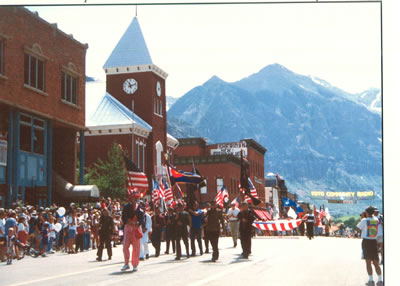
| 71.5 115.1 |
Photo |
4th of July Parade, Telluride, Colorado |
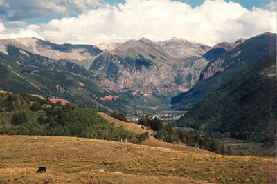
| 71.5 115.1 |
Photo |
Overview ,of Telluride, from Last Dollar Road |
| 71.8 115.5 |
San Miguel River |
After passing by the Last Dollar Road turnoff, and the T, continue west. 145 parallels the San Miguel River until it reached route 62. |
| 77.0 123.9 |
Silver Pick NFA |
Silver Pick Road National Forest Access is to the south. |
| 80.0 128.7 |
Sawpit |
At mile 80, go through the small settlement of Sawpit. Red cliffs rise on both sides of the road. |
| 81.3 130.8 |
Fall Creek Road NFA |
Fall Creek Road National Forest Access is to the left, or west at this point. |
| 83.8 134.9 |
Placerville, Colorado |
The settlement of Placerville lies at this point. |
| 84.0 135.2 |
San Miguel County Park |
The San Miguel County Park is to the right, or east side of the road as 145 heads north. |
| 84.4 135.8 |
145 and 62 Junction. |
At this point, route 145 forms a T with route 62. 145 continues left, or west through Norwood and toward Utah. Route 62 turns right and ends at Ridgway, 22 miles away. Along it are awe-inspiring views of the famous Sneffels Range. These can be seen about 13 miles toward Ridgway. - e |