| Miles Kms | Item | Summary |
|---|---|---|
| 0.0 0.0 |
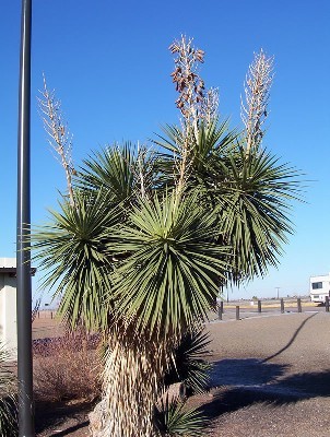
New Mexico's State Flower - The Yucca  |
Welcome to New Mexico. The Most Popular Attractions in New Mexico: Billy the Kid Museum, Fort Sumner - Carlsbad Caverns - Chaco Canyon Historic Park - The Cumbres and Toltec Scenic Railroad, Chama - International UFO Museum, Roswell - Gila Cliff Dwellings - Sandia Peak Tramway - Santa Fe The state capital - Taos Ski Valley - White Sands, Alamogordo |
| 0.0 0.0 |
Junction of Highway U.S. # 60 & U.S. # 54 |
South to city of Roswell, New Mexico. North to city of Vaughn, New Mexico -3 miles. For travel south via U.S. Highway # 54 See Milebymile.com Road Map Highway Travel Gude U.S. # 54 Charrizozo to Vaughn, for driving directions.
|
| 0.2 0.4 |
View from highway - Photo # 60 & # 285 highway signs |
Note: Highway #60 overlaps Highway #285 at this point. |
| 3.7 5.9 |
Point of Information |
Torrance, New Mexico County Line-Eastern boundary. |
| 4.5 7.2 |
Roadside turnout |
No services-North side of highway. |
| 6.5 10.5 |
 |
View from highway. |
| 13.1 21.1 |
Community of Encino, New Mexico |
Access to Encino Village Park. |
| 13.5 21.7 |
View from highway - Photo highway signs |
Junction of Highway #3. North to Villanueva State Park campground. Camping: Developed Sites (105) - Electric Sites (40) - RV Dump Station Restrooms Showers. Services at highway. |
| 14.0 22.5 |
Note |
Overlap of highway #60 ends and turns West at this point. |
| 19.5 31.4 |
Junction of County Road #33 |
East side of highway. |
| 29.3 47.2 |
 |
View from highway. |
| 40.5 65.1 |
Junction of Interstate #40 |
West to Albuquerque, New Mexico. East to Santa Rosa, New Mexico. Services at north side of highway. - Attractions in Albuquerque, New Mexico: Albuquerque Aquarium,- Alvarado Transportation Center - Beach Water Park - Cliff�s Amusement Park - New Mexico State Fair - Albuquerque International Balloon Fiesta - Lodestar Astronomy Center - National Atom Museum - Old Town Plaza - Rio Grande Botanical Gardens - Sandia Crest and Sandia Peak Aerial Tramway.
|
| 40.5 65.1 |
Note |
Highway Interstate #40 is part of the historical Route 66 Highway. |
| 43.0 69.2 |
Point of Interest |
San Miguel, County, New Mexico - Western county line. |
| 45.9 73.9 |
 |
Roadside turnout picnic area, no toilets-West side of highway. Photo is view from highway. |
| 47.2 75.9 |
Point of Information |
Santa Fe,County, New Mexico, - Southern county line. |
| 52.1 83.8 |
 |
View from highway. |
| 54.2 87.3 |
White Lake Road |
West side of highway. |
| 60.5 97.4 |
 |
View from highway. |
| 63.7 102.5 |
 |
View from highway. |
| 73.4 118.1 |
Roadside turnout |
Gravel with garbage stand-West side of highway. |
| 74.5 119.9 |
Junction of Highway #41 |
South to communities of Galisteo, New Mexico, Moriarty, New Mexico. |
| 75.1 120.8 |
Access to community of Lamy, New Mexico |
East of highway. |
| 77.2 124.3 |
 |
View from highway. |
| 80.0 128.7 |
Services at highway |
Fuel. |
| 80.8 130.1 |
Ave Amistad |
|
| 81.2 130.7 |
View from highway. |
Junction of Interstate #25. East to Las Vegas, NE. Note: Highway #285 overlaps Interstate #25 at this point.
|
| 84.3 135.6 |
 |
View from highway. |
| 87.7 141.1 |
Exit #284 (Old Pecos Trail) |
Junction of Highway #466. Access to truck route. |
| 88.7 142.7 |
View from highway - Photo - Highway sign |
|
| 89.2 143.5 |
Exit #282B |
Access to city of Santa Fe, New Mexico and Santa Fe Plaza, New Mexico. |
| 89.3 143.7 |
Exit #282A |
Access to city of Santa Fe, New Mexico. Attractions in Santa Fe: Canyon Road - the Plaza - San Miguel Mission - Guadalupe Street - Loretto Chapel (miraculous staircase), Santa Fe Opera - Santa Fe Southern Railroad Depot - Palace of the Governors - Paolo Soleri (outdoor amphitheater) - Ten Thousand Waves.
|
| 94.0 151.2 |
Exit #278 |
Junction of Highway #14. North to Santa Fe city center. North to cities of White Rock, Los Alamos. Note: Highway #14 is called the Turquoise Trail Scenic Tour Route. |
| 94.0 151.2 |
Access to Downtown Santa Fe, New Mexico |
Downtown Santa Fe. |
| 94.0 151.2 |
Downtown Santa Fe, New Mexico |
The Old El Palacio Real Fortress and Castle, built by Order of the Spanish Crown 1610 to 1612. Seat of governmnet under three flags-Spanish, Mexican, American. From 1610 to 1910 the residence of over a hundred governors and captains general. This is the oldest public building in the United States. |
| 94.0 151.2 |
Downtown Santa Fe, New Mexico |
San Miguel Church. The oldest church structure in the USA. The original adobe walls and alte were built by the Tlaxcalan Indians from Mexico under the direction of Franciscan Padres Ca 1610. |
| 94.0 151.2 |
Downtown Santa Fe, New Mexico |
This plaque marks the route of the Santa Fe Trail-Kansas City to Santa Fe. |
| 94.0 151.2 |
Downtown Santa Fe, New Mexico |
Santa Fe is home to many artistic craftsmen. These two statues took our fancy. |
| 94.0 151.2 |
Downtown Santa Fe, New Mexico |
|
| 94.0 151.2 |
Start/finish of Highway Travel Guide - Se |
For travel west via Interstate Highway # 25 See Milebymile.com Road Map Highway Travel Guide - New Mexico, # I-25 Sante Fe to Albuquerque for driving directions.
|